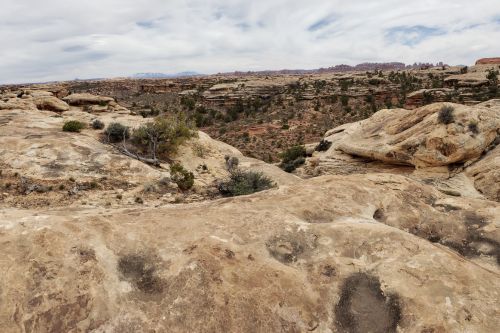
Searching for the best hikes in Canyonlands National Park might be a challenge, as each hiking trail has something unique to offer visitors. But it’s not possible to complete all seventy-five trails either. They vary from easy and moderate to strenuous and challenging.
Don’t worry; we will help you narrow down some of the most scenic hikes in Canyonlands National Park. This park has three regions: The Needles, Island in the Sky, and The Maze, divided by the Green and Colorado Rivers. Our listed hikes are centered around these regions.
Also Read:
- Best Hikes in Moab, Utah
- Sedona Wine Tasting Tours
- Waterpark Hotels in Pigeon Forge
- Cheap Motels in Cookeville, Tennessee
- Watch Sunrise from Mesa Arch
- Explore Grand View Point Overlook and Trail
- Go For an Easy Hike at White Rim Overlook Trail
- Hike Longer Following Murphy Point Trail
- Check Out the Gorgeous Upheaval Dome Overlook Trail
- Find Out Why It's Called Whale Rock Trail
- Find What's Inside Puebloan Structures at Aztec Butte
- Admire Views from Shafer Canyon Overlook Trail
- Head to Syncline Loop for a Full-Day Adventure
- Challenge Your Limit at Druid Arch Trail
- Start Early to Chesler Park Viewpoint
- See What's So Great About the Slickrock Foot Trail
- Walk Down the Dusty Confluence Overlook Trail
- Try to Guess Drawings of the Great Gallery at Horseshoe Cannon

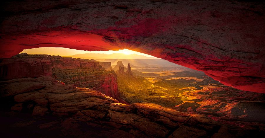
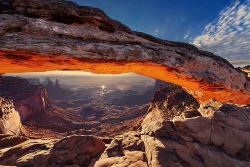
Watch Sunrise from Mesa Arch
- District: Island in the Sky
- Distance: 0.6 miles
- Time: 30 minutes
- Challenges: Some uneven ways
Oh, the iconic Mesa Arch trail! If you are in Canyonlands National Park, you must visit this place at least once. It is a short journey of 0.6 miles that won’t take much time.
This trail is the ultimate destination for photographers who want to capture gorgeous sunrise views. As shown in the above photo, the sunrise reflects the arch’s underside, basking it in a golden glow. This picturesque view can only be found in this arch in the entire park.
In addition, this trail is perfect for light hikers and kids. Even if you have a packed schedule, a hike to Mesa Arch can be squeezed due to its short distance. You might experience some uneven ways. Otherwise, this trail is not challenging.
Check These Handpicked Activities:
- Discover Moab in A Day: Arches, Canyonlands, Dead Horse Pt
- Canyonlands National Park Backcountry Tour
- Canyonlands National Park Half-Day Tour from Moab
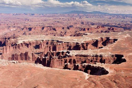
Explore Grand View Point Overlook and Trail
- District: Island in the Sky
- Distance: 1.8 miles
- Time: 1.5 hours
- Challenges: Tricky steps at the beginning
Make your next hike to the beautiful and scenic Grand View Overlook and trail. This 1.8-mile long trail has a stunning out-and-back trail that is easy to navigate. There are a few uneven and rough edges hikers must go through to see the spectacular views.
This trail is family-friendly; hence, you can bring your kids. However, dogs are forbidden here. It is open year-round and has marked signs along the path. You can hike solo without a guide.
The Grand View Overpoint trail provides 360-degree views of the Canyonlands National Park. Visitors can see the Maze, the White Rim four-wheel-drive road, and distant mountains. They look amazing when the skies are clear in the summer season.
Check These Handpicked Activities:
- Self-Guided Audio Tour in Arches and Canyonlands
- Arches and Canyonlands National Parks Self-Driving Bundle Tour
- From Moab: Canyonlands 4×4 Drive and Calm Water Cruise
Go For an Easy Hike at White Rim Overlook Trail
- District: Island in the Sky
- Distance: 1.8 miles
- Time: 1 to 2 hours
- Challenges: Little shade
This is another short and easy hike in Canyonlands National Park. The trail leads to gorgeous views of the canyons. The journey could take somewhere between one to two hours. In addition, the road is flat and kid-friendly.
First, reach the Buck Canyon Overlook in the Island in the Sky. You will have two options: the White Rim Overlook and Gooseberry/White Rim. The former is only 0.8 miles, while the latter is 3 miles. Our destination is the first, so follow the marked trail and continue heading southeast.
At the end of the route, you will see canyons, red rock formations, and Aztec Butte. From the White Rim Overlook, you can see for miles. Afterward, you can retrace your steps or explore the Gooseberry Trail.
Check These Handpicked Activities:
- Island in the Sky of Canyonlands Helicopter Tour
- Canyonlands National Park White Rim Trail by 4WD
- Canyonlands Mountain Bike Tour on the White Rim Trail
Hike Longer Following Murphy Point Trail
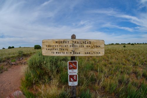
- District: Island in the Sky
- Distance: 3.4 miles
- Time: 2 hours
- Challenges: No shade
If you are up for a hike longer than a mile, Murphy Point Trail could be your destination. This relatively easy, flat hike has marked trails from the beginning. While there is little to see at the beginning, the ending will be rewarding.
Half a mile into the hike, you will see a historic corral. Slowly, the landscape opens up to scenic views of the Candlestick Tower. In addition, you will be treated to the spectacle of Green River and White Rim Road. It is worth taking pictures at this place.
Murphy Point Trail is kid-friendly so that you can travel with your family. However, it is not accessible to wheelchairs, and dogs are forbidden here.
Check These Handpicked Activities:
Check Out the Gorgeous Upheaval Dome Overlook Trail
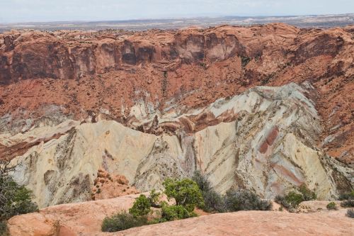
- District: Island in the Sky
- Distance: 1.7 miles
- Time: 2 to 3 hours
- Challenges: Steep trail
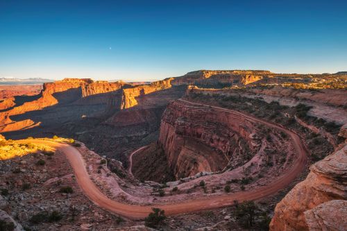
This trail leads to two overlooks along the rim of the puzzling geological structure, Upheaval Dome. Its dramatic formation has conjured up two scientific theories: the Salt Dome Theory and the Impact Crater Theory.
Geologists initially suggested the salt dome led to the formation of the Upheaval Dome. Later, a new group offered the Impact Crater Theory, which suggests a meteorite crash created the Dome. Try to find your side of the debate by hiking to this marvelous dome.
Upheaval Dome’s first overlook is only 0.6 miles long and takes about an hour. The second overlook is 1.2 miles long, taking 1.5 hours. You can visit the first overlook only or go for an extra mile with the second overlook. At the end, you will see the magnificent dome.
Check These Handpicked Activities:
- Monument Valley and Canyonlands National Park Combo Airplane Tour
- Discover Moab: Arches, Canyonlands, and La Sal Self-Guided Audio Driving Tours
Find Out Why It’s Called Whale Rock Trail
- District: Island in the Sky
- Distance: 0.8 miles
- Time: 30 minutes to 1 hour
- Challenges: Steep drop-offs
Before you ask, yes, the Whale Rock Trail is named after its whale-like structure. The long sandstone dome also has a tail and blowhole-looking areas. From the top, it looks like a beached whale.
This trail is at the end of the Upheaval Dome Road. It has handrails to help people reach the top. Or, you can enjoy free climbing. Furthermore, the top provides panoramic views of the Colorado River, Upheaval Dome, and the Green River.
Whale Rock trail is an easy hike suitable for people of all ages. Wear sturdy footwear with good traction. Overall, have a perfect and fun-filled hiking experience.
Check These Handpicked Activities:
Find What’s Inside Puebloan Structures at Aztec Butte
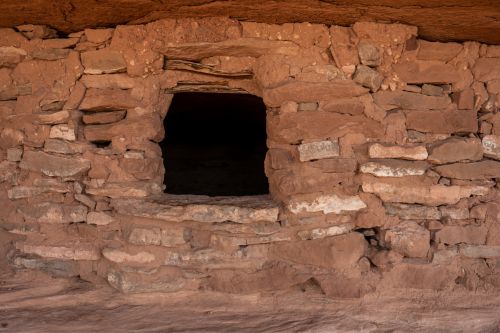
- District: Island in the Sky
- Distance: 1.4 miles
- Time: 1.5 hours
- Challenges: Scrambling
Hike up to the Aztec Butte and check out ancestral Puebloan structures. Native inhabitants used them as granaries to store their food and medicine. Although you can’t touch or enter them, it will be a marvelous sight that allows visitors to see how the ancients used to live in the 1200s and 1300s.
In addition to these stone granaries, travelers will see Mesa Arch, Muffin Butte, Green River, and Upheaval Dome. They can also see the distant views of the La Sal Mountains. And let’s not forget the eye-catching Abajo Mountains.
Aztec Butte Trail is a bit challenging. It’s a steep climb to the Slickrock slope, and it’s more difficult to descend, especially for those who fear heights, as there are no handrails. But it will be a smooth journey once you get past this hurdle.
Check These Handpicked Activities:
- Discover Canyonlands National Park: Full-Day Audio Driving Tour
- From Moab: Half-Day Canyonlands Island in the Sky 4×4 Tour
Admire Views from Shafer Canyon Overlook Trail
- District: Island in the Sky
- Distance: 0.9 miles
- Time: 30 minutes
- Challenges: No shade
Explore the historic Shafer Canyon Overlook trail on the Island in the Sky district. It was named after the early settlers, the Shafer family, who initially used the trail for ranching. It has become one of the famous hikes in Canyonlands National Park.
This 0.9-mile hiking trail is easy and family-friendly. Hikers start from the Island in the Sky visitor center and go to the Shafer Trail. It leads them through an unpaved road to the colorful Shafer Canyon. In addition, you can catch the sight of the La Sal Mountains.
As this trail is unfenced, practice caution and keep an eye on kids. If driving to the Shafer Canyon, watch for low overhanging rocks and check the weather forecast before your journey. Finally, try not to drive beyond the trail.
Check These Handpicked Activities:
- Arches and Canyonlands 4X4 Adventure from Moab
- Exciting and Scenic Off-Road Guided Tour of Moab’s Backcountry!!!
Head to Syncline Loop for a Full-Day Adventure
- District: Island in the Sky
- Distance: 8.5 miles
- Time: 6 to 8 hours
- Challenges: Rock scrambling, strenuous
Island in the Sky primarily offers easy, short hikes, but if you’re looking for a challenge, head to Syncline Loop. This 8.5-mile trail is not for everyone and will push you past your limits. Only hike there if you are experienced and have a good physique.
This trail is also called primitive and includes rock scrambling, steep climbs, and rugged ways. Avoid the summer season, as the temperature soars to extreme levels during those days. It’s best to hike in the spring and fall seasons.
The Syncline Loop trail goes around the Upheaval Dome. From the trailhead, you can choose to hike clockwise or counter-clockwise. The hike starts easily with a flat walk; it gets steep with switchbacks in the middle and becomes strenuous near the top.
But the gorgeous views of Upheaval Dome and the surroundings make it all worth it. If you visit Canyonlands National Park, keep this hike on your bucket list.
Check These Handpicked Activities:
- Sunset Scenic Private Tour of Canyonlands & Dead Horse Pt
- Day of Photography in Moab, Arches & Canyonlands
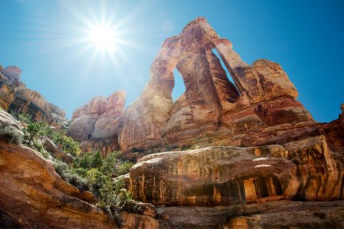
Challenge Your Limit at Druid Arch Trail
- District: The Needles
- Distance: 10.8 miles
- Time: 5 to 7 hours
- Challenges: Strenuous
If there is the most challenging trail in Canyonlands National Park, it has to be Druid Arch at The Needles. It’s not for first-time hikers and even poses a challenge for experienced ones. In addition, this trail takes between 5 to 7 hours and is a full-day trip.
The spring and fall seasons are the best time to go on this hike. While the summer is too hot for walking, winter has short days, and hikers might not have enough daylight to complete the hike: pack water, sturdy footwear, sunscreen, a map, and light.
But what makes Druid Arch Trail so famous among hikers? It’s probably the stunning views of the Needles that accompany you throughout the hike. There is also a gigantic M-shaped stone arch that will be unlike anything you have ever seen. Try to see how short you look compared to this magnificent rock formation.
Check These Handpicked Activities:
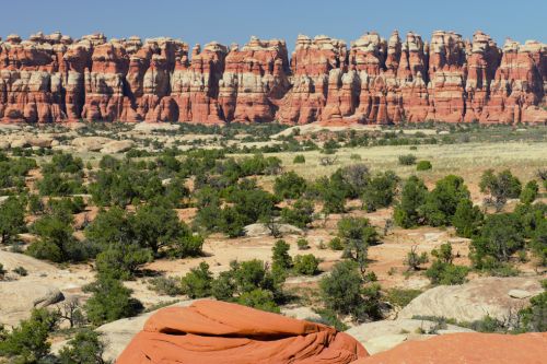
Start Early to Chesler Park Viewpoint
- District: The Needles
- Distance: 5.8 miles
- Time: 3 to 4 hours
- Challenges: Slickrock, rock scrambling
This is another strenuous hike in the Needles district after the Druid Arch Trail. It begins at the Elephant Hill trailhead and leads to the Squaw Flats campground. Hikers will then come across a narrow slot canyon named Elephant Canyon.
After three miles or so, visitors finally arrive at Chesler Park, where the views are out of this world. From this viewpoint, you will see panoramic views of the Needles district. Finally, rest and snap pictures.
Visitors can also camp out at the Chesler Park Campground. You can return the same way or continue hiking to Druid Arch. As this is a long hike, be prepared physically and mentally to walk for hours.
Check These Handpicked Activities:
- Canyonlands National Park Needles District by 4×4
- Thrilling Guided You-Drive Hells Revenge UTV Tour In Moab, UT
See What’s So Great About the Slickrock Foot Trail
- District: The Needles
- Distance: 2.4 miles
- Time: 1 hour
- Challenges: No shade
This 2.4-mile trail loops around Little Spring Canyon and Big Spring Canyon. It has four viewpoints that offer scenic views of the Needles district. Furthermore, this hiking trail has markings and signs, making navigating and following the route more accessible.
The Slickrock Foot Trail is also called introductory hiking. It is best for the first-timers and teaches them about hiking on Slickrock. Likewise, experienced hikers can take a break from their pace and leisurely enjoy walking on this route. It will be a great half-day hiking plan.
Visitors can hike clockwise or counter-clockwise from the trailhead. They will walk for less than two hours to reach four viewpoints. From there, they can see panoramic views of Six-Shooter Peak, La Sal Mountains, Little Spring Canyon, Big Spring Canyon, and most areas of the Needles.
Check These Handpicked Activities:
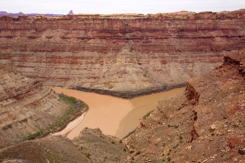
Walk Down the Dusty Confluence Overlook Trail
- District: The Needles
- Distance: 11 miles
- Time: 5 to 6 hours
- Challenges: Scrambling, No shade
As shown in the picture, this trail overlooks the confluence of the Colorado and Green Rivers. It is a strenuous 11-mile journey with rough roads, rock scrambles, and no shade. However, signs along the way lead visitors right to the destination.
The Confluence Overlook Trail leads hikers to the final viewpoint from the Big Spring Canyon Overlook, Elephant Canyon, and Cyclone Canyon. On their way, they will see panoramic views of the Junction Butte, La Sal Mountains, Abajo Mountains, Cedar Mesa Sandstone, and The Grabens.
After arriving at the Confluence Overlook, you will see the confluence of the Green and Colorado Rivers. You can also enjoy the views of the Maze District, the Island in the Sky District, and much of the Needles District.
Check These Handpicked Activities:
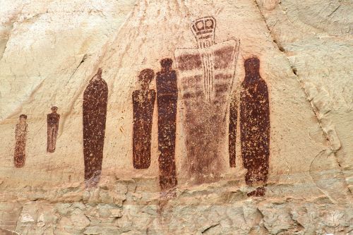
Try to Guess Drawings of the Great Gallery at Horseshoe Cannon
- District: Horseshoe Canyon
- Distance: 7 miles
- Time: 5 hours and above
- Challenges: Sandy, Slickrock, No Shade
Finally, we have the iconic Great Gallery, which is more like a huge rock art panel. It is 200 feet long and full of unique designs and drawings. Ancients made these artworks, reportedly 1500 to 4000 years old. Some are clear to understand, whereas some are puzzling.
It’s fascinating how the Great Gallery is located in the middle of nowhere in Horseshoe Canyon. Hiking is challenging from the beginning, with rough trails and no shade. Nonetheless, visitors will be in for a treat after the long hike in the sandy way.
The spring and fall seasons are best for this hiking. Try to avoid the summer season as much as possible. The temperature could reach 100 degrees Fahrenheit, which might lead to heatstroke. Finally, visitors are forbidden from touching the panel and camping around the Great Gallery.
Check These Handpicked Activities:
- Mountain Bike Expedition in the Maze District of Canyonlands
- Dead Horse Point Half-Day Guided Mountain Biking Tour in Moab
Canyonlands National Park is a heaven for hiking lovers. While hiking is fun, be prepared for a hot and rocky experience in this park. Some of these trails are physically challenging, so pre-research about the place before you go. You can look at our list or read guides.
In addition to hiking, Canyonlands offers adventurous activities like rafting, mountain biking, and water cruises. You can check them out on our TourTeller site. Overall, have a great trip to this national park. Safe travels.