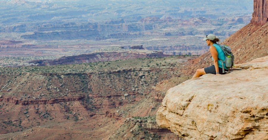
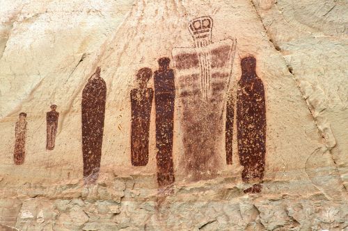
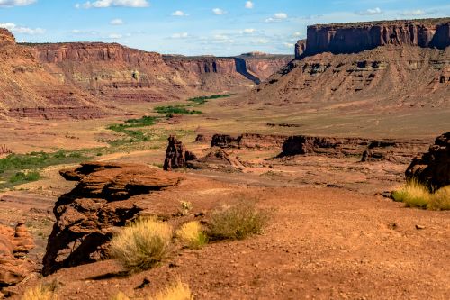
Looking for the best hikes in Moab? Then you have come to the right place. Here, we will guide you through challenging and fun hiking trails with mesmerizing views. Be prepared to walk extra miles; some hiking trips could stretch for five hours.
But why choose Moab for hiking adventures? This Utah town boasts excellent trails with scenic views at the final destination. Moreover, visitors can choose from easy, moderate, or challenging trails; plenty of options exist. It will be a fun-filled, adventurous experience for you and your family.
Also Read:
- Sedona Wine Tasting Tours
- All You Need To Know about Sedona Vortex – Where To Visit & How To Experience
- 45 Top Hawaii Tours Plus The Best Things to do in Hawaii
- Cheap Motels in Cookeville, Tennessee
- Explore Hiking Trails in Arches National Park
- Challenge Yourself with Canyonlands National Park Hikes
- Hike to the Top of Fisher Towers
- Get Tired Hiking at Dead Horse Point State Park
- Walk on Steep Roads to Hidden Valley Trail
- Enjoy a Scenic Hike to Hunter Canyon Trail
- Find Dinosaur Footprints at Dinosaur Tracks Trails
- Follow Dinosaur Footsteps to Mill Canyon Dinosaur Bone Trail

Explore Hiking Trails in Arches National Park
- Address: Utah, USA; Google Map
- Opening Hours: 8 AM – 4 PM
Moab has many hiking trails, but if you want to explore the best options, head to Arches National Park. There are forty-five trails to choose from, each offering jaw-dropping scenic views. Furthermore, they vary from easy and moderate to long and strenuous.
While we can’t discuss all available hiking trails, let’s discuss some of the best down below:
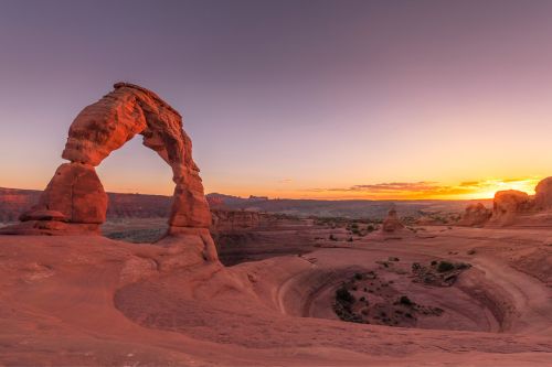
Delicate Arch Trail
- Distance: 3 miles
- Time: 1.5 to 2 hours
- Challenges: Steep Slickrock slope with no shade
Let’s start with Delicate Arch viewpoint trails in the Arches National Park. This gigantic stone arch is one of the world’s famous geologic features. It’s also known as Salt Walsh Arch, Cowboy’s Chaps, and Old Maid’s Bloomers.
The trail to this 46-foot-high and 32-foot-wide arch is a bit challenging. Visitors must climb up a steep, slick rock slope 5-6 feet wide. Be careful when walking, as it’s a straight-down drop from the path. Also, there is not much shade, and you won’t be able to see the arch until the end.
Dogs are not allowed on Delicate Arch Trail. Reaching the destination could take up to two hours of strenuous journey, but the gorgeous scenery makes it all worth it.
Check These Handpicked Activities:
Devil’s Garden Trail
- Distance: 7.9 miles
- Time: 3 to 5 hours
- Challenges: Uneven surfaces, Narrow ledges, Steep pathways
Are you up for challenging hiking routes in Arches? Devil’s Garden Trail is a popular hiking trail that is busy throughout the year. It should be partly due to this route’s difficult level that challenges hikers to their limits.
Many might be curious about the reasons behind Devil’s Garden Trail’s name. While there are many folklores, some believe the area is named after rattlesnakes residing there. There is even a belief that this place’s rough terrain is because only the devil can travel through it.
The Devil’s Garden Trail includes Double O Arch, Dark Angel, Landscape Arch, and the primitive loop trail. Visitors can hike only one of them or travel all trails in one trip. The trail is a fabulous challenge with rough terrain, narrow ledges, and rock scrambling.
Check These Handpicked Activities:
- Private Sunset Hike At Devil’s Garden Arches National Park
- Arches Devils’ Garden Primitive Loop Hike Private
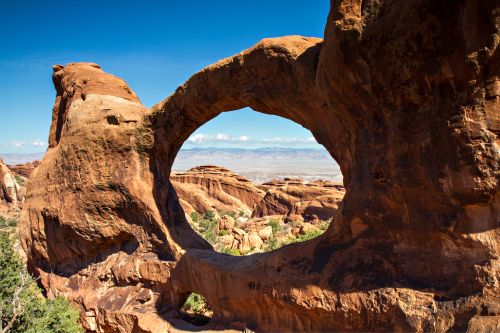
Double O Arch Trail
- Distance: 4.1 miles
- Time: 1.5 to 2 hours
- Challenges: Might get dizzy, rock scrambling
Double O Arch is located within the Devil’s Garden Trail. It is one of the most challenging hiking routes, with dry and rocky paths. In addition, this trail is not for those who fear heights. You might get dizzy and experience vertigo.
In addition, this trail is a year-round destination with gorgeous views. It is near the Dark Angel Spur Trail, Landscape Arch, and Primitive Loop Trail, and visitors can traverse all of these trails on their trip.
The Double O Arch trail takes one to two hours or more to reach. But take your time and walk slowly to your destination. Savor the pleasure that comes with hiking, and enjoy your trip.
Check These Handpicked Activities:
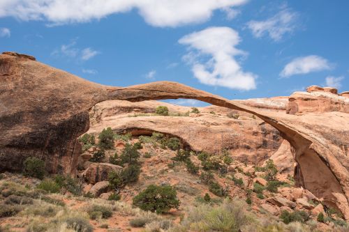
Landscape Arch Trail
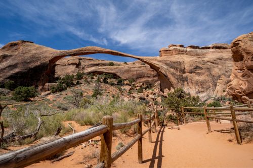
- Distance: 1.8 miles
- Time: 30 to 60 minutes
- Challenges: Few steep slopes
Take a break from rugged hiking trails and enjoy a leisurely walk on the Landscape Arch Trail. It is only 30 to 60 minutes long, and visitors can stroll to their heart’s content. This trail has a few steep slopes, but it’s an easy hike.
Landscape Arch Trail is in Devil’s Garden Trail and is North America’s longest arch. It is 6 feet in diameter and 306 feet tall. Sadly, parts of this arch collapsed on September 1, 1991. Since then, visitors have been forbidden from hiking beneath the arch.
You can still enjoy climbing the areas around Landscape Arch. Take pictures, have picnics, and make memories in this beautiful landscape.
Check These Handpicked Activities:
Park Avenue Viewpoint and Trail
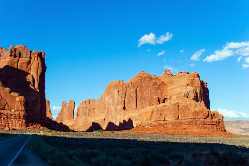
- Distance: 1.8 miles
- Time: 1 hour
- Challenges: It could be windy in the area
Park Avenue Viewpoint could be the perfect introductory hike for visitors. This trail runs down a spectacular canyon to Courthouse Towers, offering gorgeous desert and cliff views from the beginning to the end.
This is an easy hike suitable for people of all ages. The trail is well-maintained so that you won’t get lost. Furthermore, hikers will see many rock features throughout their trip. These rock formations are named The Courthouse Tower, Three Gossips, Queen Nefertiti, The Tower of Babel, Sausage Rock, and Queen Victoria.
While no barrier is on the way, the area tends to get windy during the daytime. So, wear hats, puffy coats, or rain jackets. Other than that, enjoy hiking with your friends and family.
Check These Handpicked Activities:
- From Moab: Half-Day Arches National Park 4×4 Driving Tour
- Arches National Park: Driving Tour with Audio Guide
Sand Dune Arch Trail
- Distance: 0.4 miles
- Time: 15 to 30 minutes
- Challenges: Slippery ways
If you want to take your kids hiking in Arches National Park, Sand Dune Arch could be your destination. It is a short, easy hike just 0.2 miles from the Broken Arch Trailhead. The arch is tucked away between sandstone fins.
As its name suggests, the Sand Dune Arch trail is surrounded by sand. After all the walking, you can enjoy a lovely shade under this arch. Furthermore, hikers can go further to Broken Arch or return home from the same trail.
The hike to Sand Dune is easy, with only one narrow section. It doesn’t take long to reach the arch. Some can cover the area within 13 minutes. However, don’t attempt to climb the arch or jump off from it.
Check These Handpicked Activities:
- Arches National Park 4×4 Adventure from Moab
- Discover Moab in A Day: Arches, Canyonlands, Dead Horse Pt
- High Adventure Hummer Tour on Hell’s Revenge
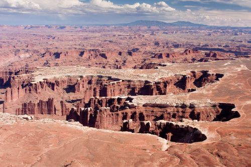
Challenge Yourself with Canyonlands National Park Hikes
- Address: Utah, USA, Google Map
- Opening Hours: 24 hours a day
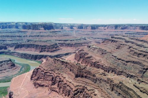
Visiting Canyonlands National Park should be on your to-do list in Moab. This year-round destination is renowned for its hiking trails, attractions, rock climbing, and stargazing. Try hiking and explore the available routes in our article for a daytime activity.
Canyonlands is divided into three regions: Island in the Sky, The Maze, and The Needles. While all offer many hiking options, check out the more popular ones down below:
Mesa Arch
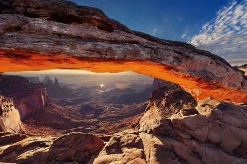
- Distance: 0.6 miles
- Time: 30 minutes
- Challenges: Few uneven ways
Start the Canyonlands National Park hiking trip with a short Mesa Arch trail. This popular destination among locals and tourists is known for its picturesque views. Many photographers come to this place to snap pictures of sunrise.
Visitors can start their journey early to watch the marvelous sunrise views. The trail is rough and uneven in some places, so walk cautiously. If traveling before dusk, bring torch lights to navigate the way.
Mesa Arch faces the La Sal Mountains on the Island in the Sky. The hike to the arch only takes thirty minutes, so it is suitable for short hikes.
Check These Handpicked Activities:
- Canyonlands National Park Half-Day Tour from Moab
- Canyonlands National Park Self-Guided Driving Audio Tour
Grand View Point Overlook and Trail
- Distance: 1.8 miles
- Time: 1.5 hours
- Challenges: The beginning steps are tricky
Another Island in the Sky hiking trail, Grand View Point Overlook, is easy, flat, and requires little effort. The beginning steps are a bit challenging, but otherwise, the hike goes smoothly without any barriers.
As its name suggests, this place offers spectacular views of the canyon. You can see The Maze, The Needles, White Rim Road, Green Rivers, and distant mountains. After reaching the top, you can return or explore other trails in Canyonlands National Park.
Check These Handpicked Activities:
- Island in the Sky of Canyonlands Helicopter Tour
- Discover Canyonlands National Park: Full-Day Audio Driving Tour
Aztec Butte Trail
- Distance: 1.4 miles
- Time: 1.5 hours
- Challenges: Rock scrambling
Contrary to its name, the Aztec Butte Trail is not connected to ancient Aztec civilization. It leads climbers from a steep slope to a unique dome-shaped butte, which early inhabitants used as a granary to store food and medicines.
Aztec Butte is a moderately leveled hike with only a few challenges. Climbers must scramble up steep slopes and ledges to the top. Moreover, this is an ancient structure that is very fragile. Hence, touching or climbing is strictly forbidden. You can hang around the walls and take pictures.
Check These Handpicked Activities:
- From Moab: Half-Day Canyonlands Island in the Sky 4×4 Tour
- Canyonlands and Arches National Park: Scenic Airplane Flight
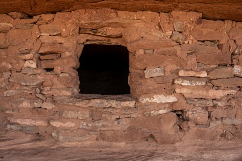
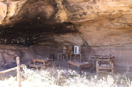
Cave Spring Trail
- Distance: 0.6 miles
- Time: 45 minutes
- Challenges: Some rock scrambling
Nestled in the Needles District, Cave Spring Trail is a short loop that requires hikers to climb two ladders to reach the final destination. Climbers will walk through a historic cowboy camp to reach Cave Spring, which Native Americans used as a natural shelter in the past.
The first ladder leads hikers to see the spectacular views. The second ladder leads to a higher place where you can see the La Sal Mountains, Six Shooter Peak, and prehistoric rock markings. Also, don’t worry about ladders; they are sturdy and can hold your weight.
Check These Handpicked Activities:
- Moab: Hell’s Revenge 4WD Off-Road Tour by Kawasaki UTV
- Moab: Self-Drive 2.5-Hour Hells Revenge 4×4 Guided Tour
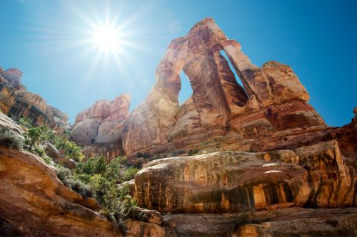
Druid Arch Trail
- Distance: 10.8 miles
- Time: 5 to 7 hours
- Challenges: Scrambling, Slippery, Strenuous
Let’s amp up our hiking tour with a strenuous trail, Druid Arch in the Needles. Hikers sign up for a whole day trip on this trail that lasts 5 to 7 hours. It will challenge them to their utmost limits for sure.
This adventurous out-and-back hiking trail leads climbers through rocky and steep sections to a magnificent arch shaped like the alphabet “M.” This place experiences exceptionally sunny weather in the summer, so it is best to save your trip for the spring or fall seasons.
As this is a challenging hike, only experienced hikers are advised to embark on it. Make sure to bring water, snacks, and sturdy footwear. After all the preparations, begin your 5-7-hour hike to Druid Arch.
Check These Handpicked Activities:
- Canyonlands National Park Needles District by 4×4
- Needles Canyonlands 4X4 Jeep Tour from Moab (3-Person Minimum)
Horseshoe Canyon’s Great Gallery
- Distance: 7 miles
- Time: 5 hours or more
- Challenges: Unpredictable weather, Slickrock
Horseshoe Canyon’s Great Gallery is located in the Maze district and is accessible from UT 24, Green River, or Hans Flat Ranger Station. It is a pictograph panel housing over twenty historic images, believed to be 1500 to 4000 years old.
The hike to the Great Gallery takes 5 to 7 hours and includes steep rocky sections, uneven terrains, and dirt roads. Hikers will pass through the High Gallery, Alcove Panel, and Horseshoe Shelter Gallery to reach their ultimate destination. Hence, it will be a visual treat for the eyes throughout the journey.
Camping, hunting, and bringing pets are prohibited near the Great Gallery. However, you can camp in the campground nearby. Also, be wary of changing weather here and avoid the rainy season as much as possible.
Check These Handpicked Activities:
- Mountain Bike Expedition in the Maze District of Canyonlands
- Canyonlands National Park Airplane Tour
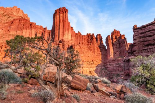
Hike to the Top of Fisher Towers
- Distance: 5.2 miles
- Time: 2 to 3 hours
- Challenges: No shade
A short distance from Moab lies Fisher Towers, gigantic red rock formations. Initially called Pipe Organs, they were created in the 1800s. Each tower has different names, including Ancient Art, King Fisher, the Titan, the Oracle, and the Cottontail Tower.
Hiking is the best activity for tourists, among many other things. The Fisher Towers Trail is only 2 to 3 hours long and easy to follow. Hikers won’t have much difficulty on this trip, except for less shady areas and a few muddy spots. It also offers spectacular views that you won’t find anywhere else.
This 5.2-mile round-trip hike leads climbers through sharp canyons and vertical cliffs to magnificent towers. The pathway is rocky and muddy, so prepare your best hiking boots. Furthermore, the hike has no shade, so it’s best to avoid sunny weather or plan accordingly.
Fisher Towers offers other activities in addition to hiking. For instance, rafting and full-day outings have become popular among visitors.
Check These Handpicked Activities:
- Fisher Towers Half-Day Rafting Day Trip from Moab
- Fisher Towers Rafting Full-Day Trip from Moab
- Fisher Towers Rafting Experience from Moab
Get Tired Hiking at Dead Horse Point State Park
- Location: UT-313, Moab, UT 84532; Google Map
- Opening Hours: 9 AM – 5 PM
- Entry Fee: $20 per vehicle
Visit Dead Horse Point State Park to enjoy hiking and mountain biking in the same area. This park is a year-round destination for camping, stargazing, biking, and more. If you are hiking, traveling in the spring or fall is best.
This park has many hiking trails ranging from easy to strenuous for you to choose from. Check them out down below:
- West Rim Trail: This hike is the longest trail to the Dead Horse Point Overlook. It offers views of the La Sal Mountains and Abajos.
- Big Horn Overlook Trail: This 1.5-mile hiking trail is moderate and leads to Big Horn Canyon.
- Shafer Canyon Overlook: This short hike offers magnificent views of Shafer Canyon and the Colorado River 2,000 ft below.
- Meander Overlook Trail: This trail, which can be reached through the West Rim Trail, offers views of the Colorado River.
- Dead Horse Point Overlook Trail: This trail is best for hiking, mountain biking, bird watching, and sightseeing.
- East Rim Trail: This is an easy hike that is 1.5 to 2 miles long. It starts from the visitor center and leads to the Dead Horse Point Overlook.
- Great Pyramid Loop Trail: This is an intermediate-leveled 4.2-mile trail that includes The Intrepid, Great Pyramid, and Big Chief.
- Colorado River Overlook Trail: This mile-long, easy hiking trail takes hikers to the visitor center through another overlook of the Colorado River.
Also, Check These Handpicked Activities:
- Private Group Half-Day Dead Horse Point Mountain Biking Tour
- Dead Horse Point Half-Day Guided Mountain Biking Tour in Moab
- Sunrise photography in Dead Horse Point and Canyonlands National Park
Walk on Steep Roads to Hidden Valley Trail
- Distance: 1 mile
- Time: 30 to 60 minutes
- Challenges: Little Shade, No cell service
If visiting Joshua Tree National Park is part of your schedule, you might as well include a hiking trip from Hidden Valley Trail. This mile-long trail loops around the park and shows its landscapes, flora, and fauna. It only takes 30 to 60 minutes to hike and will allow you plenty of time to stroll around.
This hike begins near the Hidden Valley Picnic Area. From the parking lot, you will see a map detailing the direction to the valley. A well-marked trail will take you through the stony steps in a loop around the Hidden Valley.
Hikers don’t have to worry about getting lost, as there are signs along the path. The signs also include interesting facts about the surroundings, animal life, and plants. The Hidden Valley Trail is perfect for solo hikers who enjoy peace and solitude. Also, try to catch the sunset view from the valley; they are amazing.
Check These Handpicked Activities:
- 25+ National Parks Self-Guided Driving Tours Bundle
- Utah Mighty 5 National Parks Self-Driving Audio Tours
Enjoy a Scenic Hike to Hunter Canyon Trail
- Distance: 3.4 miles
- Time: 1 to 2 hours
- Challenges: Muddy ways during the rainy season
It is challenging to find pet-friendly hiking trails in Moab. Bring your dogs to Hunter Canyon Trail and let your furry friends accompany you. It will be a fun-filled journey lasting one or two hours.
Visitors start their journey at the Hunter Canyon and Kane Creek Canyon junction. They will cross a small creek and follow it to small cliffs, narrow canyons, and arches. Furthermore, past 1.7 miles from the trailhead, hikers arrive at short stone ledges with large shallow pools. This is the perfect place to rest, snap photos, and have lunch.
You can continue hiking for another half mile or return to the trailhead. Although there is little elevation gain, Hunter Canyon Trail is a fun, easy-to-navigate hike. You can leisurely reach the destination and come back.
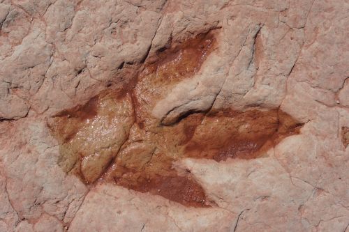
Find Dinosaur Footprints at Dinosaur Tracks Trails
- Distance: 0.2 miles
- Time: 15 to 30 minutes
- Challenges: Easy Hike
Did you know Moab has traces of dinosaurs’ existence? Dinosaur Stomping Grounds, Copper Ridge, Mill Canyon, and Hell’s Revenge contain traces of Triassic, Jurassic, and Cretaceous-age dinosaurs. You can also see dinosaur tracks in Moab Giants Dinosaur Park.
If you want to include hiking in your sightseeing tour, head over to Dinosaur Tracks Trail. It will lead you through a dirt road to a large flat boulder with dinosaur tracks. This short hike is also family-friendly so that you can take your pets.
You don’t have to pay an entrance fee or get permits. You can follow USGS Moab maps to navigate the way. Furthermore, Dinosaur Tracks Trail is a year-round destination for hikers to visit anytime. Have fun trying to guess which tracks belonged to which period’s dinosaur.
Check These Handpicked Activities:
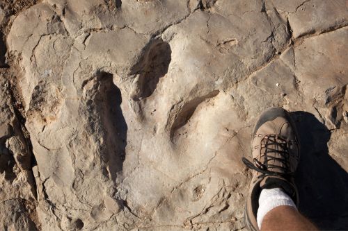
Follow Dinosaur Footsteps to Mill Canyon Dinosaur Bone Trail
- Distance: 1.8 miles
- Time: 30 to 40 minutes
- Challenges: Rough road, muddy, slippery
Mill Canyon Dinosaur Bone Trail could be your next stop if you want to continue your dinosaur sightseeing excursion. It offers front-row access to dinosaur fossils and tracks, including traces of Allosaurus, Stegosaurus, Camarasaurus, and Camptosaurus.
This hiking trail is easy to navigate and is often full of hikers. Informative signs are placed near dinosaur fossils. Moreover, this trail is kid and dog-friendly. Visitors can come with their family for a day trip.
Hikers must travel in designated trails and avoid walking in track-bearing areas. They are forbidden from carving, removing, or collecting fossils. Also, clean after yourselves and recycle trash. Overall, Mill Canyon Dinosaur Bone Trail is a historic site, so try not to cause any damage to the place.
Check This Handpicked Activity:
Moab Hikes are plenty, and each offers spectacular views and a unique experience. You can take long walks in Arches and Canyonlands National Parks or enjoy a short hike at Hidden Valley Trail and Fishers Tower Trail. You can also explore dinosaur fossils at Mill Canyon Dinosaur Bone Trail. Choose however many you want from this list of the best hikes in Moab.
Visitors must be well-prepared before hiking in these regions. Be ready to face harsh sun rays on most of these hiking trails. Pack sunscreen, water, maps, and insect repellent. Finally, do a pre-research about the trail before beginning your journey.